Файл:Falkland Islands topographic map-en.svg
Битнең эчтәлекләре башка телләрдә бирелми.
Wikipedia — ирекле энциклопедия проектыннан ([http://tt.wikipedia.org.ttcysuttlart1999.aylandirow.tmf.org.ru/wiki/Falkland Islands topographic map-en.svg latin yazuında])

Төп файл(SVG файлы, шартлы 2550 × 1990 нокта, файлның зурлыгы: 1,97 Мб)

Бу файл Викиҗыентык проектыннан һәм башка проектларда кулланылырга мөмкин. Файл турында тулырак мәгълүмат түбәндә күрсәтелгән.

 
  This SVG map uses required raster graphics to show delicate structures.
Рәвеш of the year
Рәвеш of the year
Featured рәвеш

ВикиҗыентыкВикипедия

This file was a candidate in Picture of the Year 2007.
This is a featured picture on Wikimedia Commons (Featured pictures) and is considered one of the finest images.

 This is a featured picture on the инглиз language Wikipedia (Featured pictures) and is considered one of the finest images.

If you have an image of similar quality that can be published under a suitable copyright license, be sure to upload it, tag it, and nominate it.


Pour agrandir l'image

Detailed map of large dimension. For a better viewing, click on the link of the image above.
Carte détaillée de grande dimension. Pour une visualisation optimale, cliquer sur le lien de l'image ci-dessus.

Тасвирлама

Тасвирлама
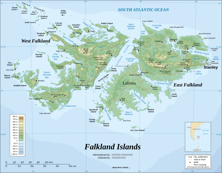
English: The Falkland Islands are an archipelago in the South Atlantic Ocean, located 300 miles off the coast of Argentina. They consist of two main islands, East Falkland and West Falkland, together with about 700 smaller islands. Stanley, on East Falkland, is the capital and largest city. The islands are a self-governing Overseas Territory of the United Kingdom.
Français : Carte topographique en anglais des Îles Malouines. Les Malouines forment un archipel dans l'Océan Atlantique Sud à 480 km des côtes argentines. Il est composé de deux îles principales, East Falkland et West Falkland, et de 700 autres îles et îlots. Stanley, sur East Falkland, est la capitale et la plus grande agglomération de l'archipel. Les Malouines sont un territoire autonome du Royaume-Uni.
Nederlands: Topografische kaart van de Falklandeilanden, een Brits overzees gebiedsdeel in de Zuidelijke Atlantische Oceaan. De archipel bestaat uit twee hoofdeilanden en ongeveer 700 kleinere op ongeveer 300 kilometer uit de kust van Argentinië. Stanley op het eiland 'East Falkland' is de hoofdstad en tergelijkertijd de meest bevolkte gemeente van het eilandengroep.De eilanden zijn een 'self-governing Overseas Territory' van het Verenigd Koninkrijk van Groot-Brittannië en Noord-Ierland.
Português: Mapa topográfico (em inglês) das Ilhas Malvinas, um arquipélago no sul do Oceano Atlântico, a 300 milhas da costa da Argentina. Consiste de duas ilhas, Soledad a leste e Gran Malvina, a oeste, junto com cerca de 700 outras ilhotas. A capital (e maior cidade) é Stanley. As Malvinas são um território autónomo do Reino Unido.
SVG‑разработка
InfoField
 
Исходный код этого SVG-файла корректен.
 
Это map было создано с помощью Inkscape
{| cellspacing="8" cellpadding="0" style="clear:both; width:100%; margin:0.5em auto; border:2px solid #88A; background-color:#F7F8FF;" lang="en" dir="ltr"

|align="center"|Translate this file |width="100%"| This SVG file contains embedded text that can be translated into your language, using any capable SVG editor, text editor or the SVG Translate tool. For more information see: About translating SVG files.

|}
Дата November 2007 using elements from the original version of April 2007
Чыганак Own work ;
Topographic map : NASA Shuttle Radar Topography Mission (SRTM3 v.2) (public domain) edited with dlgv32 Pro/Global Mapper and vectorized with Inkscape ; UTM projection ; WGS84 datum ; shaded relief (composite image of N-W, W and N lightning positions) ;
Approximate scale of topographic data and shore / lakes limits : 1:705,000 ; of the bathymetry : 1:3.720.000
Bathymetry : USGov public domain data provided by the Demis add-on for World Wind (see the approval e-mail) ;
Other references used for additional data :
* UK government map ;
* NASA World Wind ;
* CIA map available on the site of the University of Texas at Austin ;
* Microsoft Encarta atlas (1999 edition).
Note : The shaded relief is a raster image embedded in the SVG file which increases its size. If you want a lighter map for other purposes, delete the shaded relief image in your file.
Булдыручы
Eric Gaba (Sting - fr:Sting)
Рөхсәт
(Бу файлны кабат куллану)
Attribution and Share-Alike required
Georeferencing Georeference the map in Wikimaps Warper If inappropriate please set warp_status = skip to hide.
Башка юрамалар

Derivative works of this file:

[үзгәртү]


Лицензияләү

Я, владелец авторских прав на это произведение, добровольно публикую его на условиях следующих лицензий:
GNU head Бу документтан күчермә алырга, аны таратырга һәм/яки үзгәртергә Ирекле программалар фонды тарафыннан бастырылган 1.2 һәм соңрак чыгарышлы GNU Free Documentation License шартлары буенча хакыгыз бар, әмма үзгәрмәс бүлекләрсез, алгы һәм арткы тышлыктагы текстсыз. Лицензиянең күчермәсе GNU Free Documentation License исемле бүлеккә кертелгән.
w:ru:Creative Commons
атрибуция шул ук кагыйдәләр буенча таратыла
Әлеге файл Creative Commons Attribution-Share Alike 3.0 Unported лицензиясе буенча рөхсәт ителгән.
Сез ирекле рәвештә:
  • уртаклашырга – бу язмадан күчермә алырга, таратырга һәм тапшырырга
  • юрамалар ясау – бу язманы үзгәртергә
Түбәндәге шартларда:
  • атрибуция – Сез тиешле бәя, лицензиягә сылтама бирергә һәм үзгәрешләр кертелгәнме-юкмы икәнен күрсәтергә тиешсез. Сез моны теләсә-нинди дөрес булган ысул белән эшли аласыз, әмма лицензиар сезне яки куллануыгызны хуплый дигән фикер калырга тиеш түгел.
  • шул ук кагыйдәләр буенча таратыла – Әгәр сез бу әсәрне үзгәртәсез, әверелдерәсез яки аның нигезендә яңаны булдырасыз, башлангыч әсәрнең рөхсәтнамәсен яки башлангыч рөхсәтнамәгә туры килә торган рөхсәтнамәне кулланырга тиешсез.
Этот признак лицензирования был добавлен к этому файлу как часть обновления лицензии GFDL.
w:ru:Creative Commons
атрибуция шул ук кагыйдәләр буенча таратыла
Этот файл доступен на условиях лицензий Creative Commons Attribution-Share Alike 2.5 Generic, 2.0 Generic и 1.0 Generic.
Сез ирекле рәвештә:
  • уртаклашырга – бу язмадан күчермә алырга, таратырга һәм тапшырырга
  • юрамалар ясау – бу язманы үзгәртергә
Түбәндәге шартларда:
  • атрибуция – Сез тиешле бәя, лицензиягә сылтама бирергә һәм үзгәрешләр кертелгәнме-юкмы икәнен күрсәтергә тиешсез. Сез моны теләсә-нинди дөрес булган ысул белән эшли аласыз, әмма лицензиар сезне яки куллануыгызны хуплый дигән фикер калырга тиеш түгел.
  • шул ук кагыйдәләр буенча таратыла – Әгәр сез бу әсәрне үзгәртәсез, әверелдерәсез яки аның нигезендә яңаны булдырасыз, башлангыч әсәрнең рөхсәтнамәсен яки башлангыч рөхсәтнамәгә туры килә торган рөхсәтнамәне кулланырга тиешсез.
Сез теләгән лицензияне сайлый аласыз.

Краткие подписи

Добавьте однострочное описание того, что собой представляет этот файл

Элементы, изображённые на этом файле

тасвирланган феномен

MIME-тип рус

image/svg+xml

Файл тарихы

Файлның нинди булганлыгын күрү өчен «дата/вакыт» дигәненә басыгыз.

(өр-яңа | иң иске) (10 яңарак | ) (10 | 20 | 50 | 100 | 250 | 500) карарга
Дата/вакытКече рәсемҮлчәмнәреКулланучыИскәрмә
агымдагы23 авг 2021, 02:5123 авг 2021, 02:51 юрамасы өчен кече рәсем2550 × 1990 (1,97 Мб)Praça de MaioFile uploaded using svgtranslate tool (https://svgtranslate.toolforge.org/). Added translation for tr.
23 авг 2021, 02:5023 авг 2021, 02:50 юрамасы өчен кече рәсем2550 × 1990 (1,97 Мб)Praça de MaioFile uploaded using svgtranslate tool (https://svgtranslate.toolforge.org/). Added translation for tr.
6 апр 2017, 11:546 апр 2017, 11:54 юрамасы өчен кече рәсем2550 × 1990 (1,91 Мб)RaviC+ New Haven Ferry
19 дек 2008, 18:3819 дек 2008, 18:38 юрамасы өчен кече рәсем2550 × 1990 (1,93 Мб)StingReverted to version as of 03:38, 14 November 2007: please upload the translated version under a specific name
19 дек 2008, 18:2619 дек 2008, 18:26 юрамасы өчен кече рәсем2550 × 1990 (1,93 Мб)Vitekthis is just croatian translation
14 ноя 2007, 03:3814 ноя 2007, 03:38 юрамасы өчен кече рәсем2550 × 1990 (1,93 Мб)StingNew version more accurate and with shaded relief
16 июн 2007, 01:1816 июн 2007, 01:18 юрамасы өчен кече рәсем2550 × 1990 (1,03 Мб)StingReverted to earlier revision
16 июн 2007, 01:0316 июн 2007, 01:03 юрамасы өчен кече рәсем2550 × 1990 (2,14 Мб)StingTrying to fix the bug on WP-en #8
16 июн 2007, 00:4016 июн 2007, 00:40 юрамасы өчен кече рәсем2550 × 1990 (2,01 Мб)StingTrying to fix the bug on WP-en #7 (really boring...)
16 июн 2007, 00:2916 июн 2007, 00:29 юрамасы өчен кече рәсем2550 × 1990 (2,08 Мб)StingTrying to fix the bug on WP-en #6 (OK, the problem comes from the shaded relief raster image)
(өр-яңа | иң иске) (10 яңарак | ) (10 | 20 | 50 | 100 | 250 | 500) карарга

Бу файлны кулланган битләр юк.

Файлның гомуми кулланышы

Әлеге файл аста бирелгән викиларда куллана:

Бу файлның гомуми кулланышын карау.

Метабирелмәләр