
Файл:Hopetoun falls.jpg

Алдан карауның зурлыгы: 800 × 533 нокта. Башка ачыклык: 320 × 213 нокта | 640 × 427 нокта | 1024 × 683 нокта | 1280 × 853 нокта | 2560 × 1707 нокта | 3072 × 2048 нокта.
Төп файл (3072 × 2048 нокта, файл зурлыгы: 2,82 Мб, MIME төре: image/jpeg)
|

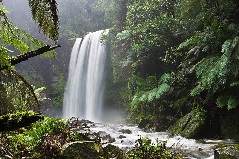
Эта иллюстрация выбрана изображением дня для 17 марта 2006 года. У неё следующее описание: Русский: Водопад Хоупентон (Австралия, Виктория) Другие языки
Alemannisch: D Hepetoun-Wassrfäll in Victoria, Australie Čeština: Vodopády Hopetoun Falls ve Viktorii v Austrálii Deutsch: Die Hopetoun-Fälle in Victoria (Australien) English: The Hopetoun Falls is a waterfall in Victoria, Australia. Español: Catarata Hopetoun en Victoria (Australia) Français : Chutes d'eau d'Hopetoun (État de Victoria, Australie) Galego: Victoria, Australia Italiano: Le cascate Hopetoun, stato di Victoria, Australia Lëtzebuergesch: D'Hepetoun-Fäll, Victoria (Australien). Norsk nynorsk: Hopetounfalla i Victoria i Australia. Polski: Wodospad Hopetoun w Wiktorii (Australia) Português: A Queda de água de Hopetoun é uma cascata em Victoria, Austrália. Suomi: Hopetoun-putoukset Victoriassa, Australiassa. Български: Водопадът Хопетоун във Виктория, Австралия Русский: Водопад Хоупентон (Австралия, Виктория) العربية : ثي&é"-الا |
Тасвирлама
| Тасвир |
English: Hopetoun Falls, Beech Forest, near Otway National Park, Victoria, Australia. Taken with a Canon 10D and 17-40 f/4L lens.
Français : Cascade de Hopetoun, Forêt de Beech, près du Parc National d'Otway, état de Victoria, Australie. Image prise avec un Canon 10D et un objectif 17-40 f/4L.
العربية: شلالاتُ هوبتون العملاقة في غابة الزان بالقربِ من حديقة أوتواي الوطنية في مدينة فيكتوريا، أستراليا. |
| Дата | |
| Чыганак | Үз эшем |
| Автор | Diliff |
| Рөхсәт (Бу файлны кабат куллану) |
Summary:In using this image or any subsequent derivatives of it, you are required to release the image under the same license. As such, any reproduction of this image, in any medium, must appear with a copy of, or full URL of the license.Attribution of this image to the author (DAVID ILIFF) is also required, preferably in a prominent location near the image.No other conditions may be added to, or removed from this license without the permission of the author and copyright holder.Suggested attribution: "Photo by DAVID ILIFF. License: CC BY-SA 3.0"Please review the full license requirements carefully before using this image. If you would like to clarify the terms of the license or negotiate less restrictive commercial licensing outside of the bounds of GFDL/CC-BY-SA, please contact me by email, or if you don't have a Wikipedia account you can either leave a message on my talk page with your contact details and your request, or you can contact me on Facebook. Please also send a 'friend request' to ensure that I am aware of your message. |
| Башка юрамалар |

| Местоположение камеры | | Это и другие изображения по их местоположению на OpenStreetMap |
|---|
Лицензияләү
Я, владелец авторских прав на это произведение, добровольно публикую его на условиях следующих лицензий:
Әлеге файл Creative Commons Attribution-Share Alike 3.0 Unported лицензиясе буенча рөхсәт ителгән.
Авторлыкны күрсәтү: Photo by DAVID ILIFF
- Сез ирекле рәвештә:
- уртаклашырга – бу язмадан күчермә алырга, таратырга һәм тапшырырга
- юрамалар ясау – бу язманы үзгәртергә
- Түбәндәге шартларда:
- атрибуция – Сез тиешле бәя, лицензиягә сылтама бирергә һәм үзгәрешләр кертелгәнме-юкмы икәнен күрсәтергә тиешсез. Сез моны теләсә-нинди дөрес булган ысул белән эшли аласыз, әмма лицензиар сезне яки куллануыгызны хуплый дигән фикер калырга тиеш түгел.
- шул ук кагыйдәләр буенча таратыла – Әгәр сез бу әсәрне үзгәртәсез, әверелдерәсез яки аның нигезендә яңаны булдырасыз, башлангыч әсәрнең рөхсәтнамәсен яки башлангыч рөхсәтнамәгә туры килә торган рөхсәтнамәне кулланырга тиешсез.

|
Бу документтан күчермә алырга, аны таратырга һәм/яки үзгәртергә Ирекле программалар фонды тарафыннан бастырылган 1.2 һәм соңрак чыгарышлы GNU Free Documentation License шартлары буенча хакыгыз бар, әмма үзгәрмәс бүлекләрсез, алгы һәм арткы тышлыктагы текстсыз. Лицензиянең күчермәсе GNU Free Documentation License исемле бүлеккә кертелгән. |
Сез теләгән лицензияне сайлый аласыз.
Файл тарихы
Файлның нинди булганлыгын күрү өчен «дата/вакыт» дигәненә басыгыз.
| Дата/вакыт | Кече рәсем | Үлчәмнәре | Кулланучы | Искәрмә | |
|---|---|---|---|---|---|
| агымдагы | 13 окт 2009, 19:06 | | 3072 × 2048 (2,82 Мб) | Diliff | Reupload original file at 3072x2048 res |
| 30 окт 2005, 02:27 |  | 1400 × 933 (667 Кб) | Diliff | Hopetoun Falls, Beech Forest, near Otway National Park, Victoria. Taken on the 27th of July, 2005 with a Canon 10D and 17-40 f/4L lens. |
Файлны куллану
Әлеге файл киләсе битне куллана:
Файлның гомуми кулланышы
Әлеге файл аста бирелгән викиларда куллана:
- af.wikipedia.org проектында куллану
- ang.wikipedia.org проектында куллану
- an.wikipedia.org проектында куллану
- ar.wikipedia.org проектында куллану
- azb.wikipedia.org проектында куллану
- az.wikipedia.org проектында куллану
- ba.wikipedia.org проектында куллану
- bcl.wikipedia.org проектында куллану
- be-tarask.wikipedia.org проектында куллану
- beta.wikiversity.org проектында куллану
- be.wikipedia.org проектында куллану
- bg.wikipedia.org проектында куллану
- bh.wikipedia.org проектында куллану
- bn.wikipedia.org проектында куллану
- bo.wikipedia.org проектында куллану
- br.wikipedia.org проектында куллану
- bs.wikipedia.org проектында куллану
- ca.wikipedia.org проектында куллану
- ceb.wikipedia.org проектында куллану
- ce.wikipedia.org проектында куллану
- ckb.wikipedia.org проектында куллану
- ckb.wiktionary.org проектында куллану
- cs.wikipedia.org проектында куллану
- cv.wikipedia.org проектында куллану
- cy.wikipedia.org проектында куллану
Бу файлның гомуми кулланышын карау.