
Тоба (күл): юрамалар арасында аерма
| Юл номеры - 68: | Юл номеры - 68: | ||
Smaller eruptions have occurred at Toba since. The small cone of [[Pusukbukit]] has formed on the southwestern margin of the caldera and lava domes. The most recent eruption may have been at [[Tandukbenua]] on the northwestern caldera edge, since the present lack of vegetation could be due to an eruption within the last few hundred years.<ref>{{Cite web|url=http://www.volcanodiscovery.com/volcano-tours/volcanoes/indonesia/sumatra/toba/|title=Toba volcano (Indonesia, Sumatra)|publisher=VolcanoDiscovery.com}}</ref> |
Smaller eruptions have occurred at Toba since. The small cone of [[Pusukbukit]] has formed on the southwestern margin of the caldera and lava domes. The most recent eruption may have been at [[Tandukbenua]] on the northwestern caldera edge, since the present lack of vegetation could be due to an eruption within the last few hundred years.<ref>{{Cite web|url=http://www.volcanodiscovery.com/volcano-tours/volcanoes/indonesia/sumatra/toba/|title=Toba volcano (Indonesia, Sumatra)|publisher=VolcanoDiscovery.com}}</ref> |
||
Some parts of the caldera have experienced uplift due to partial refilling of the [[magma chamber]], for example pushing [[Samosir|Samosir Island]] and the [[Uluan Peninsula]] above the surface of the lake. The lake sediments on Samosir Island show that it has been uplifted by at least {{convert|450|m|0|abbr=on}}<ref name=OregonState/> since the cataclysmic eruption. Such uplifts are common in very large calderas, apparently due to the upward pressure of unerupted [[magma]]. Toba is probably the largest resurgent caldera on Earth. Large [[earthquake]]s have occurred in the vicinity of the volcano more recently, notably in 1987 along the southern shore of the lake at a depth of {{convert|11|km|abbr=on}}.<ref>{{cite web|url=http://earthquake.usgs.gov/eqcenter/eqarchives/significant/sig_1987.php|title=Significant Earthquakes of the World|publisher=[[United States Geological Survey]] (USGS)}}</ref> Other earthquakes have occurred in the area in 1892, 1916, and 1920–1922.<ref name=OregonState>{{Cite web|url=http://volcano.oregonstate.edu/vwdocs/volc_images/southeast_asia/indonesia/toba.html|title=Toba, Sumatra, Indonesia|publisher=[[Oregon State University]]}} |
Some parts of the caldera have experienced uplift due to partial refilling of the [[magma chamber]], for example pushing [[Samosir|Samosir Island]] and the [[Uluan Peninsula]] above the surface of the lake. The lake sediments on Samosir Island show that it has been uplifted by at least {{convert|450|m|0|abbr=on}}<ref name=OregonState/> since the cataclysmic eruption. Such uplifts are common in very large calderas, apparently due to the upward pressure of unerupted [[magma]]. Toba is probably the largest resurgent caldera on Earth. Large [[earthquake]]s have occurred in the vicinity of the volcano more recently, notably in 1987 along the southern shore of the lake at a depth of {{convert|11|km|abbr=on}}.<ref>{{cite web|url=http://earthquake.usgs.gov/eqcenter/eqarchives/significant/sig_1987.php|title=Significant Earthquakes of the World|publisher=[[United States Geological Survey]] (USGS)}}</ref> Other earthquakes have occurred in the area in 1892, 1916, and 1920–1922.<ref name=OregonState>{{Cite web|url=http://volcano.oregonstate.edu/vwdocs/volc_images/southeast_asia/indonesia/toba.html|title=Toba, Sumatra, Indonesia|publisher=[[Oregon State University]]}}]</ref> |
||
Lake Toba lies near the [[Great Sumatran fault]] which runs along the centre of Sumatra in the [[Great Sumatran fault|Sumatra Fracture Zone]].<ref name=OregonState/> The volcanoes of Sumatra and Java are part of the [[Sunda Arc]], a result of the northeasterly movement of the [[Indo-Australian Plate]] which is sliding under the eastward-moving [[Eurasian Plate]]. The [[subduction zone]] in this area is very active: the seabed near the west coast of Sumatra has had several major earthquakes since 1995, including the 9.1 [[2004 Indian Ocean Earthquake]] and the 8.7 [[2005 Sumatra earthquake]], the epicenters of which were around {{convert|300|km|abbr=on}} from Toba. |
Lake Toba lies near the [[Great Sumatran fault]] which runs along the centre of Sumatra in the [[Great Sumatran fault|Sumatra Fracture Zone]].<ref name=OregonState/> The volcanoes of Sumatra and Java are part of the [[Sunda Arc]], a result of the northeasterly movement of the [[Indo-Australian Plate]] which is sliding under the eastward-moving [[Eurasian Plate]]. The [[subduction zone]] in this area is very active: the seabed near the west coast of Sumatra has had several major earthquakes since 1995, including the 9.1 [[2004 Indian Ocean Earthquake]] and the 8.7 [[2005 Sumatra earthquake]], the epicenters of which were around {{convert|300|km|abbr=on}} from Toba. |
||
5 июн 2012, 05:05 юрамасы
| |||||||||||||||

Тоба күле (индон. Danau Toba) - 2°41′04″ т. к. 98°52′32″ кч. о.HGЯO урнашкан күл һәм супер-янартау. Күл озынлыгы 100 километр, киңлеге 30 километр. Индонезияның Суматра утравының төньяк өлешенең уртасында урнашкан күл 2°53′ т. к. 98°31′ кч. о.HGЯO белән 2°21′ т. к. 99°06′ кч. о.HGЯO нокталары арасында сузыла. Индонезияның иң эре һәм дөньяның иң эре янартау күле булуы мәгълүм.[1]
Геология
Атылу

Атылу Көньяк Азияны якынча 15 см көл юрганы каплады; үзәк Һиндстандагы бер җирлегендә бүгенге көндә сакланган көл юрганы тирәнлеге 6 м[2], Малайзия кайбер урыннарында 9 м янартау көле белән капланган иде.[3] Монын өстеннән, вакыйга нәтиҗәсендә атмосферага кислота яңгырына китергән 10 000 миллион тонна күкерт кислотасы[4] [чыганагы?] яки 6 000 миллион тонна күкерт диоксиды[5] эләгүенә китергән.
Соңгы арадагы активлык
2010 елның 26 октябрь көне Индонезияның Пагай-селатан утравының 36 км көньяк-көнбатышта 3 м бөеклектә цунами тудырган 7,7 дәрәҗәсендә җиртетрәве урын алды.
2012 елның 10 гыйнварында регионда 7,3 бөеклеге җиртетрәве урын алды.
Атылу мөмкинлеге
GRACE иярчене күрсәткәненчә, Суматра утравы тирәсендәге 2004 елгы җиртетрәве[6] Җир шарының формасын үзгәртте[7]. Якын тирәдә соңгы арада урын алган җиртетрәүләре бу колоссаль климат-үзгәртүче магма активлыгын башлата алуы мөмкин.


Кешеләрe
Флора һәм фауна
Gallery
-
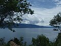 Парапаттан Тоба күле күренеше
 -
 Амбаритадан Тоба күле күренеше
 -
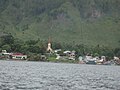 Самосир Тоба күле авыллары
 -
 Парапат лиманы
 -
 Батак авылы
 -
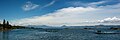 Күлнең Симаниндодан күренеше


Шулай ук карагыз
Искәрмәләр
- ↑ Worldlakes.org
- ↑ (1993) «Toba ash on the South Asia and its implications for correlation of late pleistocene alluvium». Quaternary Research 40 (1): 10–19. DOI:10.1006/qres.1993.1051.
- ↑ Scrivenor, John Brooke (1931). The Geology of Malaya. London: MacMillan. ., noted by Weber.
- ↑ (2001) «Cooling of the South China Sea by the Toba Eruption and correlation with other climate proxies ∼71,000 years ago». Geophysical Research Letters 28 (20): 3915–3918. DOI:10.1029/2000GL006113.
- ↑ (2009) «Did the Toba volcanic eruption of ~74k BP produce widespread glaciation?». Journal of Geophysical Research 114: D10107. DOI:10.1029/2008JD011652.
- ↑ Gross, Richard (October 2005). The Gravitational Signature of the December 26, 2004 Sumatran Earthquake. University of Texas Center for Space Research. December 2011 тикшерелгән.
- ↑ Satellite Data Reveals Gravity Change From Sumatran Earthquake, Ohio State University Research News (August 2006). 1 декабрь 2011 тикшерелде.
Өстәмә әдәбият
- Rampino, Michael R. and Stephen Self (1993). «Climate-volcanism feedback and the Toba eruption of 74,000 Years Ago». Quaternary Research 40 (3): 269–280. DOI:10.1006/qres.1993.1081.
- Vazquez, Jorge A. and Mary R. Reid (2004). «Probing the accumulation history of the voluminous Toba Magma». Science 305 (5686): 991–994. DOI:10.1126/science.1096994. PMID 15310899.
- Petraglia, M. et al. (2007). «Middle Paleolithic Assemblages from the Indian Subcontinent Before and After the Toba Super-Eruption». Science 317 (5834): 114–116. DOI:10.1126/science.1141564. PMID 17615356.
Сылтамалар
- Toba, Sumatra, Indonesia – Volcano.umd.edu Accessed 11 December 2005 Калып:Dead link
- Stanley H. Ambrose, Volcanic Winter, and Differentiation of Modern Humans Accessed 11 December 2005
- Joel Achenbach, Who Knew, National Geographic Accessed 11 December 2005
- George Weber, Toba Volcano
- (Lake Toba Ecosystem Management Plan) From laketoba.org
- Калып:Wikitravel