
Файл:Deepwater Horizon oil spill - May 24, 2010.jpg

Төп файл (2118 × 1628 нокта, файл зурлыгы: 369 Кб, MIME төре: image/jpeg)
Тасвирлама
| Тасвир |
English: Description from NASA (source):
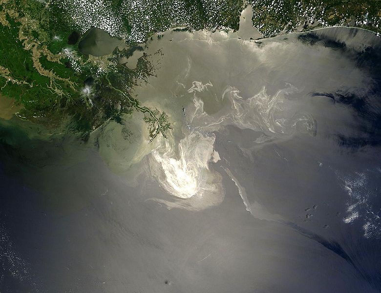
"NASA's Terra Satellites Sees Spill on May 24
Français : Traduction partielle de la description par la NASA(source): La marée noire causée par l'incendie de la plateforme pétrolière Deepwater Horizon vue par le satellite Terra, de la NASA, le 24 mai 2010.
Cette image a été acquise par le Moderate-Resolution Imaging Spectroradiometer (MODIS, pour Spectroradiomètre d'imagerie à résolution moyenne), embarqué sur le satellite Terra. Le pétrole lisse la surface de l'océan, ce qui la rend plus claire là où elle réfléchit le soleil (par exemple, au centre de la photo) et plus sombre ailleurs (par exemple en bas à droite). Le delta du Mississippi est visible en haut, entouré d'eaux saumâtres et boueuses qui apparaissent en brun, rayé de rubans argentés de pétrole. |
| Дата | |
| Чыганак | Original image, here cropped on left and at top |
| Автор | NASA/GSFC, MODIS Rapid Response |
| Башка юрамалар |
|

|

Лицензияләү
| Этот файл находится в общественном достоянии (англ. public domain), так как он был создан NASA (Национальным управлением по аэронавтике и исследованию космического пространства). Политика авторского права NASA гласит, что «Материал NASA не защищается авторским правом, если не указано иное». (См. Template:PD-USGov, страницу политики авторского права NASA или политику использования изображений JPL.) | ||
 |
Предупреждения:
|
Файл тарихы
Файлның нинди булганлыгын күрү өчен «дата/вакыт» дигәненә басыгыз.
| Дата/вакыт | Кече рәсем | Үлчәмнәре | Кулланучы | Искәрмә | |
|---|---|---|---|---|---|
| агымдагы | 26 май 2010, 05:26 | | 2118 × 1628 (369 Кб) | APK | == Summary == {{Information |Description={{en|"Sunlight illuminated the lingering oil slick off the Mississippi Delta on May 24, 2010. The Moderate Resolution Imaging Spectroradiometer (MODIS) on NASA’s Terra satellit |
Файлны куллану
Әлеге файл киләсе битне куллана:
Файлның гомуми кулланышы
Әлеге файл аста бирелгән викиларда куллана:
- af.wikipedia.org проектында куллану
- be.wikipedia.org проектында куллану
- ca.wikipedia.org проектында куллану
- cs.wikipedia.org проектында куллану
- da.wikipedia.org проектында куллану
- de.wikipedia.org проектында куллану
- el.wikipedia.org проектында куллану
- en.wikipedia.org проектында куллану
- Marine conservation
- Portal:Marine life
- Wikipedia:Featured pictures/Space/Looking back
- Wikipedia:Featured picture candidates/delist/2010
- Wikipedia:Featured pictures thumbs/23
- Wikipedia:Featured picture candidates/June-2010
- Wikipedia:ITN archives/2010/May
- Talk:Deepwater Horizon oil spill/Archive 4
- Wikipedia:Featured picture candidates/Deepwater Horizon oil spill - May 24, 2010.jpg
- Wikipedia:Wikipedia Signpost/2010-06-28/Features and admins
- User talk:APK/Archive 22
- Wikipedia:Featured picture candidates/delist/Deepwater oil spill 5-24-10
- Talk:Deepwater Horizon oil spill/Archive 10
- Wikipedia:Picture of the day/April 2012
- Template:POTD/2012-04-20
- Wikipedia:Main Page history/2012 April 20
- User talk:APK/Archive 25
- Research and Development Institute of Ecology and the Sustainable Use of Natural Resources
- Wikipedia:Wikipedia Signpost/Single/2010-06-28
- Flash-gas (petroleum)
- en.wikinews.org проектында куллану
- et.wikipedia.org проектында куллану
- fa.wikipedia.org проектында куллану
- fr.wikibooks.org проектында куллану
- he.wikipedia.org проектында куллану
- hr.wikipedia.org проектында куллану
- hu.wikinews.org проектында куллану
- hy.wikipedia.org проектында куллану
- lv.wikipedia.org проектында куллану
- ms.wikipedia.org проектында куллану
- nl.wikipedia.org проектында куллану
Бу файлның гомуми кулланышын карау.