
Файл:Sahel Map-Africa rough.png
Алдан карауның зурлыгы: 800 × 370 нокта. Башка ачыклык: 320 × 148 нокта | 640 × 296 нокта | 1024 × 474 нокта | 2000 × 925 нокта.
Төп файл (2000 × 925 нокта, файл зурлыгы: 291 Кб, MIME төре: image/png)

|
Этот файл нуждается в обновлении, по следующей причине: south soudan При этом вы можете добавить временную метку к файлу.
|
| Тасвир |
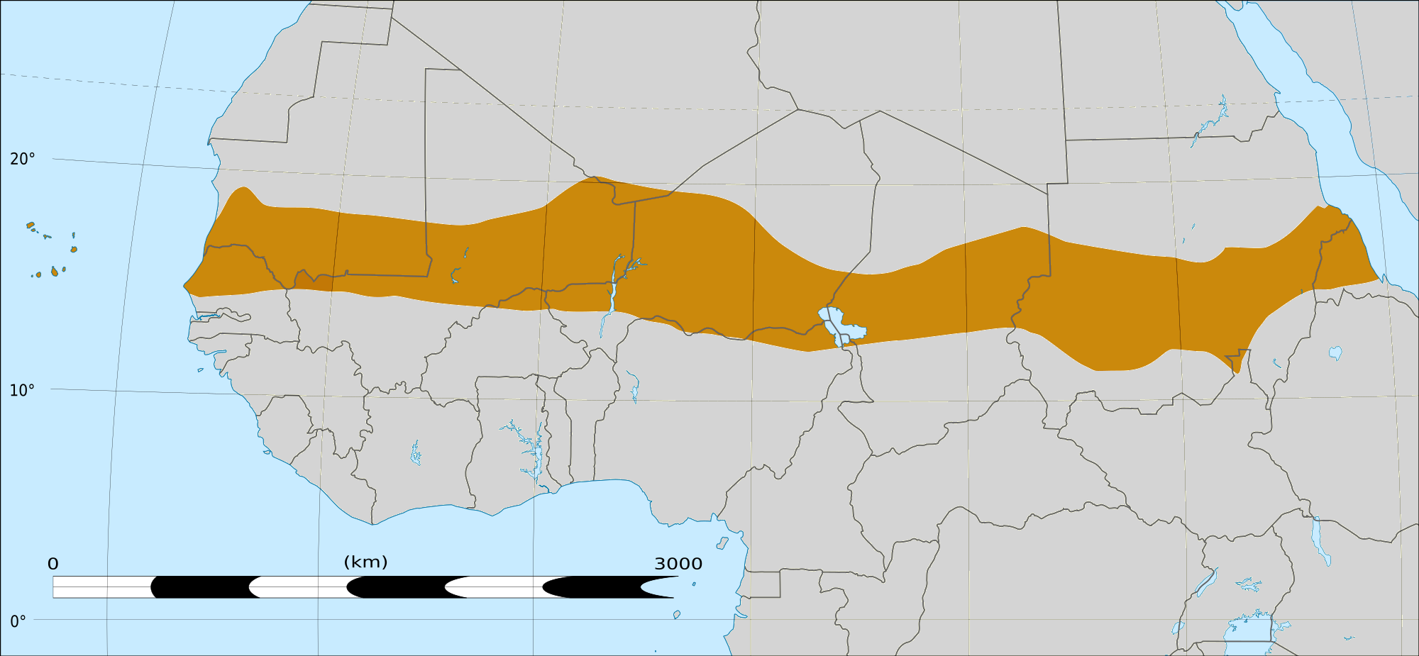
English: Map of Africa, with the Sahel highlighted in orange.
This is roughly the African land area between the lines of 200mm (north) and 600mm (south) mean 20th century annual rainfall. This is limited to land areas directly to the south of the Sahara desert and including the islands of Cape Verde, but not including other areas in Africa with the same rainfall statistics. This is one, but not the only, definition of the Sahel region. |
|||
| Дата | 20 февраль 2009 03:54 (UTC) | |||
| Чыганак |
Felix Koenig: "created/photographed by myself (based on the existing blank map of Africa)"
|
|||
| Автор | ||||
| Башка юрамалар |
|


| Это отретушированное изображение, что означает, что первоначальной версия изображения была изменена цифровым способом. Изменения: Reproduced Sahel boundary from Map sahel.jpg on png map, cropped. Оригинал доступен по ссылке: BlankMap-Africa2.png:
|
Лицензияләү
Я, владелец авторских прав на это произведение, добровольно публикую его на условиях следующих лицензий:

|
Бу документтан күчермә алырга, аны таратырга һәм/яки үзгәртергә Ирекле программалар фонды тарафыннан бастырылган 1.2 һәм соңрак чыгарышлы GNU Free Documentation License шартлары буенча хакыгыз бар, әмма үзгәрмәс бүлекләрсез, алгы һәм арткы тышлыктагы текстсыз. Лицензиянең күчермәсе GNU Free Documentation License исемле бүлеккә кертелгән. |
This file is licensed under the Creative Commons Attribution-Share Alike 4.0 International, 3.0 Unported, 2.5 Generic, 2.0 Generic and 1.0 Generic license.
- Сез ирекле рәвештә:
- уртаклашырга – бу язмадан күчермә алырга, таратырга һәм тапшырырга
- юрамалар ясау – бу язманы үзгәртергә
- Түбәндәге шартларда:
- атрибуция – Сез тиешле бәя, лицензиягә сылтама бирергә һәм үзгәрешләр кертелгәнме-юкмы икәнен күрсәтергә тиешсез. Сез моны теләсә-нинди дөрес булган ысул белән эшли аласыз, әмма лицензиар сезне яки куллануыгызны хуплый дигән фикер калырга тиеш түгел.
- шул ук кагыйдәләр буенча таратыла – Әгәр сез бу әсәрне үзгәртәсез, әверелдерәсез яки аның нигезендә яңаны булдырасыз, башлангыч әсәрнең рөхсәтнамәсен яки башлангыч рөхсәтнамәгә туры килә торган рөхсәтнамәне кулланырга тиешсез.
Сез теләгән лицензияне сайлый аласыз.
|
|
Бу документтан күчермә алырга, аны таратырга һәм/яки үзгәртергә Ирекле программалар фонды тарафыннан бастырылган 1.2 һәм соңрак чыгарышлы GNU Free Documentation License шартлары буенча хакыгыз бар, әмма үзгәрмәс бүлекләрсез, алгы һәм арткы тышлыктагы текстсыз. Лицензиянең күчермәсе GNU Free Documentation License исемле бүлеккә кертелгән. |
Исходный журнал загрузок
This image is a derivative work of the following images:
- File:Map_sahel.jpg licensed with GFDL
- 2005-05-30T17:36:46Z King 800x800 (89588 Bytes) one moment please
- File:BlankMap-Africa2.png licensed with Cc-by-sa-3.0,2.5,2.0,1.0, GFDL
- 2008-03-08T18:02:20Z Sadalmelik 1754x1546 (51013 Bytes) {{Information |Description=Blank map of Africa |Source=self-made |Date=2008-03-08 |Author= [[User:Sadalmelik|Sadalmelik]] |Permission= |other_versions= }} [[Category:Blank maps of Africa]]
Uploaded with derivativeFX
Файл тарихы
Файлның нинди булганлыгын күрү өчен «дата/вакыт» дигәненә басыгыз.
| Дата/вакыт | Кече рәсем | Үлчәмнәре | Кулланучы | Искәрмә | |
|---|---|---|---|---|---|
| агымдагы | 17 мар 2018, 16:15 | | 2000 × 925 (291 Кб) | Maphobbyist | South Sudan border |
| 20 фев 2009, 04:02 |  | 1384 × 658 (29 Кб) | T L Miles | {{Information |Description=*Description: A map of Africa: the Sahel highlighted in orange. Note, this is ROUGHLY the African land area between the lines of 200mm (north) and 600mm (south) mean 20th century annual rainfall. This is limited to land areas d |
Файлны куллану
Әлеге файл киләсе битне куллана:
Файлның гомуми кулланышы
Әлеге файл аста бирелгән викиларда куллана:
- af.wikipedia.org проектында куллану
- als.wikipedia.org проектында куллану
- ar.wikipedia.org проектында куллану
- az.wikipedia.org проектында куллану
- bcl.wikipedia.org проектында куллану
- be.wikipedia.org проектында куллану
- bg.wikipedia.org проектында куллану
- bn.wikipedia.org проектында куллану
- br.wikipedia.org проектында куллану
- ca.wikipedia.org проектында куллану
- ce.wikipedia.org проектында куллану
- da.wikipedia.org проектында куллану
- en.wikipedia.org проектында куллану
- eu.wikipedia.org проектында куллану
- fa.wikipedia.org проектында куллану
- fi.wiktionary.org проектында куллану
- fr.wikipedia.org проектында куллану
- fr.wikinews.org проектында куллану
- ha.wikipedia.org проектында куллану
- ig.wikipedia.org проектында куллану
- incubator.wikimedia.org проектында куллану
- it.wikipedia.org проектында куллану
- ja.wikipedia.org проектында куллану
- ka.wikipedia.org проектында куллану
- ko.wikipedia.org проектында куллану
- mg.wikipedia.org проектында куллану
- mk.wikipedia.org проектында куллану
Бу файлның гомуми кулланышын карау.