
Файл:Korean war 1950-1953.gif
Алдан карауның зурлыгы: 387 × 600 нокта. Башка ачыклык: 155 × 240 нокта | 562 × 871 нокта.
Төп файл (562 × 871 нокта, файл зурлыгы: 1,32 Мб, MIME төре: image/gif, әйләнешле, 20 фрейм, 30 с)
Тасвирлама
| Тасвир |
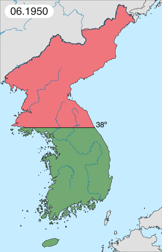
English: Map of Korean war from May 1950 to July 1951, showing:
Français : Carte de la guerre de Corée de mai 1950 à juillet 1951, montrant:
Deutsch: Karte des Koreakriegs von Mai 1950 bis Juli 1951, abgebildet:
Italiano: Mappa della guerra di Corea dal maggio 1950 al luglio 1951, rappresentante:
|
| Дата | |
| Чыганак | Үз эшем |
| Автор | Leomonaci98 |
Лицензияләү
Я, владелец авторских прав на это произведение, добровольно публикую его на условиях следующих лицензий:

|
Бу документтан күчермә алырга, аны таратырга һәм/яки үзгәртергә Ирекле программалар фонды тарафыннан бастырылган 1.2 һәм соңрак чыгарышлы GNU Free Documentation License шартлары буенча хакыгыз бар, әмма үзгәрмәс бүлекләрсез, алгы һәм арткы тышлыктагы текстсыз. Лицензиянең күчермәсе GNU Free Documentation License исемле бүлеккә кертелгән. |
| Әлеге файл Creative Commons Attribution-Share Alike 3.0 Unported лицензиясе буенча рөхсәт ителгән. | ||
| ||
| Этот признак лицензирования был добавлен к этому файлу как часть обновления лицензии GFDL. |
Сез теләгән лицензияне сайлый аласыз.
Файл тарихы
Файлның нинди булганлыгын күрү өчен «дата/вакыт» дигәненә басыгыз.
| Дата/вакыт | Кече рәсем | Үлчәмнәре | Кулланучы | Искәрмә | |
|---|---|---|---|---|---|
| агымдагы | 16 фев 2020, 20:20 | | 562 × 871 (1,32 Мб) | Leomonaci98 | Graphic update |
| 1 май 2013, 01:02 |  | 227 × 400 (85 Кб) | Spesh531 | update for every month | |
| 9 июн 2006, 08:47 |  | 227 × 400 (37 Кб) | Roke~commonswiki | rm white | |
| 8 июн 2006, 06:25 |  | 227 × 400 (37 Кб) | Roke~commonswiki | add OngJin peninsula after comment, also blank frame at end | |
| 5 июн 2006, 15:14 |  | 227 × 400 (37 Кб) | Roke~commonswiki | Korean war, showing North Korean, Chinese and communist forces (red); South Korean, US and United Nations forces (green). Category: Korean War Category: Animated maps |
Файлны куллану
Әлеге файл киләсе битне куллана:
Файлның гомуми кулланышы
Әлеге файл аста бирелгән викиларда куллана:
- af.wikipedia.org проектында куллану
- az.wikipedia.org проектында куллану
- bat-smg.wikipedia.org проектында куллану
- bg.wikipedia.org проектында куллану
- br.wikipedia.org проектында куллану
- bs.wikipedia.org проектында куллану
- ca.wikipedia.org проектында куллану
- Corea del Nord
- Corea del Sud
- Ióssif Stalin
- Mao Zedong
- Winston Churchill
- Harry Truman
- Guerra de Corea
- Kim Il-sung
- Viatxeslav Mólotov
- Gueorgui Malenkov
- Douglas MacArthur
- Lavrenti Béria
- M*A*S*H (pel·lícula)
- Clement Attlee
- Mark Wayne Clark
- Zona desmilitaritzada de Corea
- República Popular d'Hongria
- Syngman Rhee
- Peng Dehuai
- Força Aèria de l'Exèrcit Popular de Corea
- Forces Armades de Corea del Nord
- Forces Armades de la República de Corea
- 65è Regiment d'Infanteria (Estats Units)
- Frontera entre Corea del Nord i Corea del Sud
- Kim Chaek
- Batalla d'Inchon
- Plantilla:Guerra de Corea
- Pak Hon-yong
- ckb.wikipedia.org проектында куллану
- cs.wikipedia.org проектында куллану
- cy.wikipedia.org проектында куллану
- da.wikipedia.org проектында куллану
- de.wikipedia.org проектында куллану
- el.wikipedia.org проектында куллану
- en.wikipedia.org проектында куллану
Бу файлның гомуми кулланышын карау.