
Файл:MGS MOC Wide Angle Map of Mars PIA03467.jpg

Төп файл (2000 × 1288 нокта, файл зурлыгы: 534 Кб, MIME төре: image/jpeg)
Тасвирлама
| Тасвир |
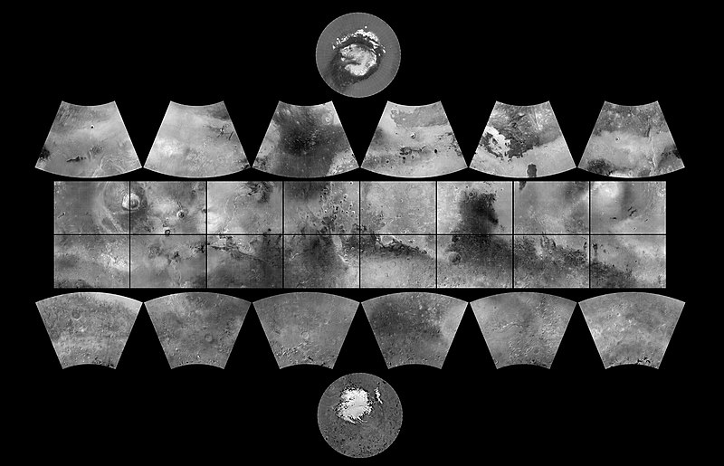
English: The MGS MOC Wide Angle Map of Mars
In 1979, NASA published ATLAS OF MARS: THE 1:5,000,000 MAP SERIES, edited by R.M. Batson, P.M. Bridges, and J.L. Inge, of the U.S. Geological Survey in Flagstaff, Arizona. This was a compendium of airbrushed shaded relief maps, controlled photomosaics, and in a few cases albedo (shading) maps, mostly assembled from Mariner 9 survey images, with some gaps filled by Viking orbiter images. The planet was divided into thirty "quadrangles" or areas, each with an "Mars Chart" or "MC" number (MC-1 through MC-30). The equatorial region was portrayed in the Mercator projection, with Lambert Conformal Conic for the mid-latitudes and Polar Stereographic for the poles. Although digital products such as the Mars Digital Image Mosaic (MDIM) and various Mars Global Surveyor (MGS) Mars Orbiter Laser Altimeter (MOLA) maps have partially supplanted the ATLAS, it remains a standard desktop reference today. In 1999, the Mars Orbiter Camera (MOC) aboard the MGS orbiter acquired a global stereo image dataset using its red-filter Wide Angle Camera. We have recently completed a 256 pixel/degree (about 230 meters/pixel) mosaic of these images using software developed at Malin Space Science Systems(MSSS). Visit the MSSS Geodesy Campaign Mosaic Page to access both partial and full-resolution mosaics in Planetary Data System format. The image above is a reproduction of the new MGS MOC Mars Digital Map and is the first of several cartographic products that MSSS expects to release this year. Malin Space Science Systems and the California Institute of Technology built the MOC using spare hardware from the Mars Observer mission. MSSS operates the camera from its facilities in San Diego, CA. The Jet Propulsion Laboratory's Mars Surveyor Operations Project operates the Mars Global Surveyor spacecraft with its industrial partner, Lockheed Martin Astronautics, from facilities in Pasadena, CA and Denver, CO. |
| Дата | (addition date) |
| Чыганак | http://photojournal.jpl.nasa.gov/catalog/PIA03467 (image link) |
| Автор | NASA/JPL/MSSS |
Это изображение или видеозапись внесены в каталог Лаборатории реактивного движения НАСА под идентификатором (Photo ID): PIA03467. Этот шаблон не указывает на правовой статус данной работы. По-прежнему необходим нормальный шаблон лицензий. См. Commons:Лицензирование. Другие языки:
|
Лицензияләү
| Этот файл находится в общественном достоянии (англ. public domain), так как он был создан NASA (Национальным управлением по аэронавтике и исследованию космического пространства). Политика авторского права NASA гласит, что «Материал NASA не защищается авторским правом, если не указано иное». (См. Template:PD-USGov, страницу политики авторского права NASA или политику использования изображений JPL.) | ||
 |
Предупреждения:
|
| Annotations | This image is annotated: View the annotations at Commons |
Файл тарихы
Файлның нинди булганлыгын күрү өчен «дата/вакыт» дигәненә басыгыз.
| Дата/вакыт | Кече рәсем | Үлчәмнәре | Кулланучы | Искәрмә | |
|---|---|---|---|---|---|
| агымдагы | 18 фев 2019, 10:19 | | 2000 × 1288 (534 Кб) | Kesäperuna | 100% JPEG quality from full quality TIFF. (Upload preceding this was 90% JPEG) |
| 18 фев 2019, 09:54 |  | 2000 × 1288 (473 Кб) | Kesäperuna | 100% JPEG quality from full quality TIFF. | |
| 12 апр 2008, 07:27 |  | 2000 × 1288 (212 Кб) | Bryan Derksen | {{Information |Description={{en|In 1999, the Mars Orbiter Camera (MOC) aboard the MGS orbiter acquired a global stereo image dataset using its red-filter Wide Angle Camera. We have recently completed a 256 pixel/degree (about 230 meters/pixel) mosaic of t |
Файлны куллану
Әлеге файл киләсе битне куллана:
Файлның гомуми кулланышы
Әлеге файл аста бирелгән викиларда куллана:
- ar.wikipedia.org проектында куллану
- az.wikipedia.org проектында куллану
- bs.wikipedia.org проектында куллану
- ca.wikipedia.org проектында куллану
- Exploració de Mart
- Cartografia de Mart
- Categoria:Quadrangles de Mart
- Categoria:Quadrangle Mare Boreum
- Categoria:Quadrangle Mare Acidalium
- Categoria:Quadrangle Diacria
- Categoria:Quadrangle Aeolis
- Categoria:Quadrangle Elysium
- Categoria:Quadrangle Ismenius Lacus
- Categoria:Quadrangle Cebrenia
- Categoria:Quadrangle Tharsis
- Categoria:Quadrangle Lunae Palus
- Categoria:Quadrangle Syrtis Major
- Categoria:Quadrangle Oxia Palus
- Categoria:Quadrangle Arabia
- Categoria:Quadrangle Amenthes
- Categoria:Quadrangle Memnonia
- Categoria:Quadrangle Phoenicis Lacus
- Categoria:Quadrangle Margaritifer Sinus
- Categoria:Quadrangle Sinus Sabaeus
- Categoria:Quadrangle Phaethontis
- Categoria:Quadrangle Thaumasia
- Categoria:Quadrangle Argyre
- Categoria:Quadrangle Noachis
- Categoria:Quadrangle Hellas
- Categoria:Quadrangle Mare Australe
- Categoria:Quadrangle Eridania
- Categoria:Quadrangle Arcadia
- Categoria:Quadrangle Casius
- Categoria:Quadrangle Coprates
- Categoria:Quadrangle Amazonis
- Plantilla:Quadrangles de Mart
- Categoria:Quadrangle Iapygia
- Categoria:Quadrangle Mare Tyrrhenum
- de.wikipedia.org проектында куллану
Бу файлның гомуми кулланышын карау.