
Файл:Abu Reyhan Biruni-Earth Circumference.svg

Төп файл (SVG файлы, шартлы 1000 × 900 нокта, файлның зурлыгы: 16 Кб)
Тасвирлама
| Тасвир |
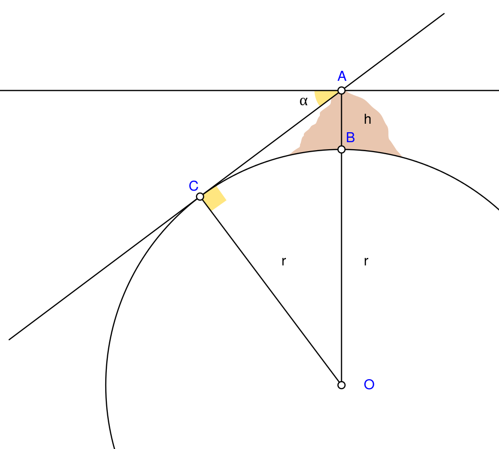
English: Biruni (973 - 1048) developed a new method using trigonometric calculations to compute earth's radius and circumference based on the angle between the horizontal line and true horizon from a mountain top with known height. He calculated the height of the mountain by going to two points at sea level with a known distance apart and then measuring the angle between the plain and the top of the mountain for both points.
Biruni's estimate of 6,339.9 km for the Earth radius had an error of 0.0026 and was 16.8 km less than the current value of 6,356.7 km. The idea came to him when he was on top of a tall mountain near Nandana in Pakistan. He measured the dip angle using an astrolabe and he applied to the law of sines formula. He also made use of algebra in his calculation.
Solution: Français : Biruni (973-1048) développa une nouvelle méthode utilisant la trigonométrie pour calculer le rayon et la ciconférence de la Terre, basée sur l'angle entre la ligne horizontale et l'horizon réel depuis le sommet d'une montagne de hauteur connue. Il calcula la hauteur de la montagne en se rendant en deux points situés au niveau de la mer dont l'écartement était connu, puis en mesurant l'angle entre la ligne horizontale formée par les deux points au niveau de la mer et le sommet de la montagne, et ceci depuis chacun des deux points.
L'estimation de Biruni de 6 339,9 km pour le rayon de la Terre comportait une erreur de 0,26 %, soit une valeur inférieure de 16,8 km par rapport à la valeur actuelle de 6 356,7 km. L'idée lui était venue alors qu'il se trouvait au sommet d'une haute montagne, près de Nandana en Inde. Il mesura l'angle d'incinaison avec un astrolabe et il appliqua la formule des sinus. Il fit également usage de l'algèbre pour ses calculs.
Solution : |
| Дата | |
| Чыганак | Үз эшем Using Geogebra and Inkscape |
| Автор | Nevit Dilmen |
| SVG‑разработка |
Лицензияләү
- Сез ирекле рәвештә:
- уртаклашырга – бу язмадан күчермә алырга, таратырга һәм тапшырырга
- юрамалар ясау – бу язманы үзгәртергә
- Түбәндәге шартларда:
- атрибуция – Сез тиешле бәя, лицензиягә сылтама бирергә һәм үзгәрешләр кертелгәнме-юкмы икәнен күрсәтергә тиешсез. Сез моны теләсә-нинди дөрес булган ысул белән эшли аласыз, әмма лицензиар сезне яки куллануыгызны хуплый дигән фикер калырга тиеш түгел.
- шул ук кагыйдәләр буенча таратыла – Әгәр сез бу әсәрне үзгәртәсез, әверелдерәсез яки аның нигезендә яңаны булдырасыз, башлангыч әсәрнең рөхсәтнамәсен яки башлангыч рөхсәтнамәгә туры килә торган рөхсәтнамәне кулланырга тиешсез.
Файл тарихы
Файлның нинди булганлыгын күрү өчен «дата/вакыт» дигәненә басыгыз.
| Дата/вакыт | Кече рәсем | Үлчәмнәре | Кулланучы | Искәрмә | |
|---|---|---|---|---|---|
| агымдагы | 2 май 2010, 05:25 | | 1000 × 900 (16 Кб) | Nevit | Crop |
| 2 май 2010, 05:21 |  | 1390 × 1220 (16 Кб) | Nevit | Yellow removed | |
| 2 май 2010, 05:19 |  | 1390 × 1220 (16 Кб) | Nevit | Image version | |
| 2 май 2010, 05:18 |  | 640 × 480 (22 Кб) | Nevit | {{Information |Description={{en|1=Biruni (973 - 1048) developed a new method using trigonometric calculations to compute earth's circumference based on the angle between the horizontal line and true horizon from a mountain top with known height. He calcu |
Файлны куллану
Әлеге файл киләсе битне куллана:
Файлның гомуми кулланышы
Әлеге файл аста бирелгән викиларда куллана:
- af.wikipedia.org проектында куллану
- ar.wikipedia.org проектында куллану
- bcl.wikipedia.org проектында куллану
- bn.wikipedia.org проектында куллану
- bs.wikipedia.org проектында куллану
- diq.wikipedia.org проектында куллану
- en.wikipedia.org проектында куллану
- es.wikipedia.org проектында куллану
- fa.wikipedia.org проектында куллану
- fr.wikipedia.org проектында куллану
- he.wikipedia.org проектында куллану
- hr.wikipedia.org проектында куллану
- id.wikipedia.org проектында куллану
- it.wikipedia.org проектында куллану
- ja.wikipedia.org проектында куллану
- ps.wikipedia.org проектында куллану
- pt.wikipedia.org проектында куллану
- pt.wikibooks.org проектында куллану
- ro.wikipedia.org проектында куллану
- ru.wikipedia.org проектында куллану
- sd.wikipedia.org проектында куллану
- sh.wikipedia.org проектында куллану
- sr.wikipedia.org проектында куллану
- ta.wikipedia.org проектында куллану
- tr.wikipedia.org проектында куллану
- uk.wikipedia.org проектында куллану
- uz.wikipedia.org проектында куллану
- www.wikidata.org проектында куллану
Бу файлның гомуми кулланышын карау.