
Файл:PIA11176 - A Recent Cluster of Impacts.jpg

Төп файл (2736 × 1824 нокта, файл зурлыгы: 569 Кб, MIME төре: image/jpeg)
Тасвирлама
| Тасвир |
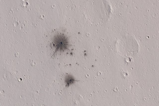
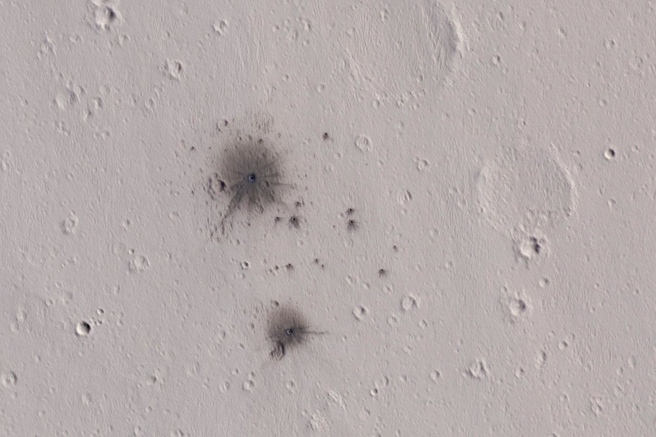
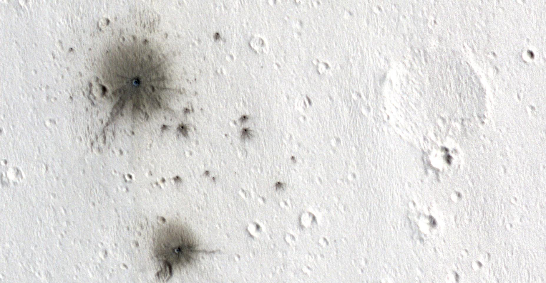
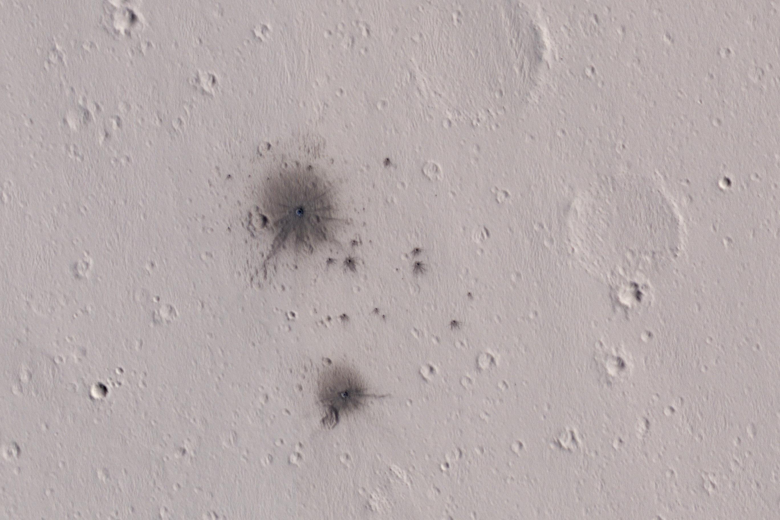
English: The dark spots in this enhanced-color infrared image are the recent impact craters that occurred in the Tharsis region between 2008 and 2014. These impact craters were first discovered by the Mars Context Camera (or CTX, also onboard the Mars Reconnaissance Orbiter) as a cluster of dark spots. The meteoroid that formed these craters must have broken up upon atmospheric entry and fragmented into two larger masses along with several smaller fragments, spawning at least twenty or so smaller impact craters.
The dark halos around the resulting impact craters are a combination of the light-toned dust being cleared from the impact event and the deposition of the underlying dark toned materials as crater ejecta. The distribution and the pattern of the rayed ejecta suggests that the meteoroid most-likely struck from the south (which is up in the cutout). HiRISE frequently monitors new impact craters similar to this one; however, this is the first image of this particular impact taken by HiRISE, thanks to a request by the CTX team. Subsequent images will likely follow to monitor if there are any changes to the site from wind-blown activity or dust-deposition over time. The University of Arizona, Tucson, operates HiRISE, which was built by Ball Aerospace & Technologies Corp., Boulder, Colo. NASA's Jet Propulsion Laboratory, a division of Caltech in Pasadena, California, manages the Mars Reconnaissance Orbiter Project for NASA's Science Mission Directorate, Washington. |
| Дата | 4 October 2016 (published 7 February 2016) |
| Чыганак | Catalog page · Full-res (JPEG · TIFF) |
| Автор | NASA/JPL-Caltech/Univ. of Arizona |
| Место на Марсе | Это и другие изображения по их местоположению на Картах Google |
|---|
Это изображение или видеозапись внесены в каталог Лаборатории реактивного движения НАСА под идентификатором (Photo ID): PIA11176. Этот шаблон не указывает на правовой статус данной работы. По-прежнему необходим нормальный шаблон лицензий. См. Commons:Лицензирование. Другие языки:
|
 |
This media is a product of the Mars Reconnaissance Orbiter mission Credit and attribution belongs to the High Resolution Imaging Science Experiment (HiRISE) team, NASA/JPL-Caltech/Univ. of Arizona |
Лицензияләү
| Этот файл находится в общественном достоянии (англ. public domain), так как он был создан NASA (Национальным управлением по аэронавтике и исследованию космического пространства). Политика авторского права NASA гласит, что «Материал NASA не защищается авторским правом, если не указано иное». (См. Template:PD-USGov, страницу политики авторского права NASA или политику использования изображений JPL.) | ||
 |
Предупреждения:
|
Файл тарихы
Файлның нинди булганлыгын күрү өчен «дата/вакыт» дигәненә басыгыз.
| Дата/вакыт | Кече рәсем | Үлчәмнәре | Кулланучы | Искәрмә | |
|---|---|---|---|---|---|
| агымдагы | 9 фев 2017, 00:59 | | 2736 × 1824 (569 Кб) | PhilipTerryGraham | User created page with UploadWizard |
Файлны куллану
Әлеге файл киләсе битне куллана:
Файлның гомуми кулланышы
Әлеге файл аста бирелгән викиларда куллана:
- ar.wikipedia.org проектында куллану
- en.wikipedia.org проектында куллану
- eu.wikipedia.org проектында куллану
- mnw.wikipedia.org проектында куллану